Overview
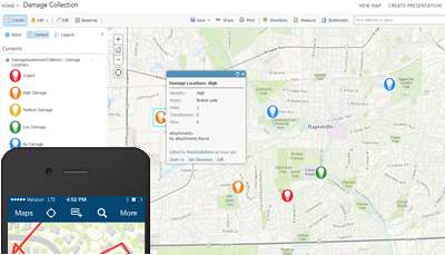
In the event of a natural disaster, the Damage Assessment Collector solution can be used by field crews to record the location, severity, and photos of damages from a mobile device. Once damages are collected from the field, managers and other office staff can view the scope of damage and impacts on the electric network in real time.
The Damage Assessment Collector is a configuration of ArcGIS. Once configured, the Damage Assessment Collector can be used to collect damages using the ArcGIS Collector app on a mobile device.
Requirements
Damage Assessment Collector requires specific technical experience and software.
| Requirement | Description |
| Software |
Solution deployment
Solution hosting
|
| Applications |
|
What you get
When you deploy Damage Assessment Collector, you'll find the following:
| Item | Name | Description |
| Map | Damage Assessment Collector | A map used by field personnel to record the location and severity of damage. |
| Feature layer | Damage Assessment | A feature layer used to store the location and severity of post disaster damage. |
What's new
Below are the release dates and notes for Damage Assessment Collector.
| Date | Description |
| November 2020 |
|
| June 2017 |
|
| January 2017 |
|
| July 2015 |
|
| March 2014 |
|
| September 2013 |
|