The ArcGIS Solutions website will no longer be available after September 1, 2025. See the latest documentation.
This item has been moved to mature support. Please see What's new for more information.
Overview
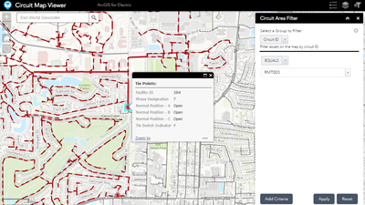
This series of maps enables utility staff, from field technicians to customer service representatives, access to basic geographic utility information. These core electric utility maps are designed to be accessible to the organization using a web browser or native client.
This solution includes the following maps:
- Facility map
- Circuit map
- Main Line Switching Diagram map
- Service Territory map
Requirements
Electric Facility Maps requires specific technical experience and software.
| Requirement | Description |
| Software |
Map authoring
Map service hosting
Application hosting
|
| Applications |
|
What you get
When you download the Electric Facility Maps, you'll find the following in the zip file:
| Directory | Item | Description |
| Maps and GDBs | CircuitMap.mxd | A map document used to publish the circuit map feature service. |
| CircuitMapGrayScale.mxd | A map document used to publish the gray scale circuit map service | |
| FacilityMap.mxd | A map document used to publish the electric facility service. | |
| MainLineSwitchingDiagramMap.mxd | A map document used to publish the main line switching diagram Map feature service. | |
| MainLineSwitchingDiagramGrayScaleMap.mxd | A map document used to publish the gray scale main line switching diagram map service. | |
| ServiceTerritoryMap.mxd | A map document used to publish the service territory service. | |
| ElectricNetwork.gdb | A sample geodatabase containing sample electric network data. | |
| Icons | A folder containing icons for the services, maps, and apps. | |
What's new
Below are the release dates and notes for Electric Facility Maps.
| Date | Description |
| November 2020 |
|
| September 2016 |
|
| July 2015 |
|