Overview
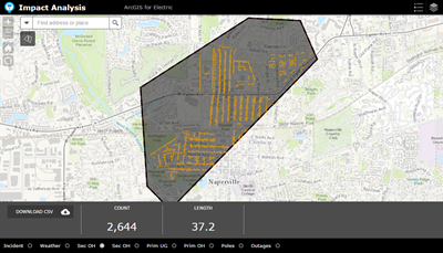
Impact Analysis can be used by utility staff to identify the impact of an incident, such as a wind storm, on infrastructure. Utilities can also use it as a planning tool to analyze and understand potential outages, safety concerns, and restoration cost.
Impact Analysis is a configuration of Web AppBuilder for ArcGIS that can be used to analyze the impact to electric facilities within an incident area. The incident can be saved as a feature service and the summarizations of assets can be exported to a CSV. This analysis can then be shared to best prepare for the incident.
Requirements
Impact Analysis requires specific technical experience and software.
| Requirement | Description |
| Software |
Map authoring
Map service hosting
Application hosting
|
| Applications |
|
| Prerequisite |
|
What you get
When you download Impact Analysis, you'll find the following in the zip file:
| Directory | Item | Description |
| Maps and GDBs | ImpactArea.mxd | A map document used to publish the impact area feature service. |
| ImpactArea.gdb | A sample geodatabase containing the schema to save the results of the impact analysis. | |
| Icons | A folder containing icons for the services, maps, and apps. | |
What's new
Below are the release dates and notes for Impact Analysis.
| Date | Description |
| November 2020 |
|
| December 2015 |
|