Overview
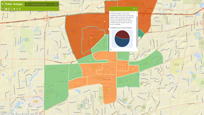
The Public Outage map solution allows a utility to inform customers about the electric system's status by region. This map includes different geographic regions to display summaries of customer in and out of service, as well as a percentage of customers out of service. Optionally, you can display the locations of outage events.
The outage information is created through a series of geoprocessing models. The results are then shared to an ArcGIS organization to provide the public with a scalable map that can handle heavy demands when there is a large outage.
Requirements
Public Outage requires specific technical experience and software.
| Requirement | Description |
| Software |
Map authoring
Map service hosting
Application hosting
|
| Applications |
|
What you get
When you download the Public Outage map, you'll find the following in the zip file:
| Directory | Item | Description |
| Maps and GDBs | PublicOutages.mxd | A map document used to publish the public outage service. |
| PublicOutagesStaging.mxd | A map document used to run the outage geoprocessing models and create the outage service data. | |
| PublicOutages.gdb | A sample geodatabase with sample outage and service area data. | |
| PublicOutages.tbx | A toolbox with tools to calculate outage details by customer and event, and calculate the total number of customers. | |
| Icons | A folder containing icons for the services, maps, and apps. | |
What's new
Below are the release dates and notes for Public Outage.
| Date | Description |
| November 2020 |
|
| July 2015 |
|
| September 2013 |
|