This item has been moved to mature support. Please see What's new for more information.
Overview
These series of maps enable all utility staff, from field technicians to customer service representatives, access to basic geographic utility information. Gas Facility Maps is designed to be accessible using a web browser or native client like the Explorer for ArcGIS application.
This solution offers a map based view of the following:
- Cathodic Protection System and Soil Corrosivity
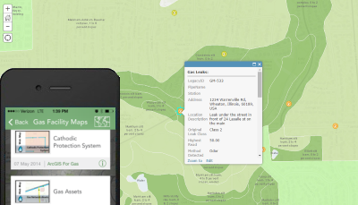
- Gas Leaks and Soil Type
- Gas Facilities
- Gas Pressure
- Isolation Areas
- Service Area
Requirements
Gas Facility Maps requires specific technical experience and software.
| Requirement | Description |
| Software | Map Authoring
Map service hosting
Application hosting
|
| Applications |
|
What you get
When you download the Gas Facility Maps, you'll find the following in the zip file:
| Directory | Item | Description |
| Maps and GDBs | CathodicProtection.mxd | A map document used to publish the Cathodic Protection System service. |
| GasLeaks.mxd | A map document used to publish the Gas Leaks service. | |
| GasNetwork.mxd | A map document used to publish the Gas Network service. | |
| GasPressure.mxd | A map document used to publish the Gas Pressure service. | |
| IsolationAreas.mxd | A map document used to publish the Isolation Areas service. | |
| ServiceArea.mxd | A map document used to publish the Service Area service. | |
| NapervilleGas.gdb | A sample geodatabase with gas network and service territory data. | |
| Icons | A folder containing icons for the services, maps, and apps. | |
What's new
Below are the release dates and notes for Gas Facility Maps.
| Date | Description |
| November 2020 |
|
| April 2016 |
|
| October 2015 |
|
| July 2015 |
|
| December 2014 |
|
| June 2014 |
|