The ArcGIS Solutions website will no longer be available after September 1, 2025. See the latest documentation.
This item has been moved to mature support. Please see What's new for more information.
Overview
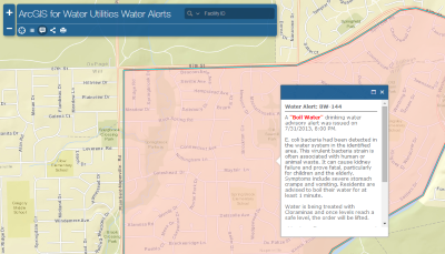
During a planned or unplanned event, it is essential for a utility to communicate with the public about drinking water alerts or advisories. One method of communicating drinking water alert or advisory information is using the Drinking Water Advisory solution.
The map based view of drinking water advisories or alerts allows for customers to view areas with affected service. This map also includes additional information, such as precautions to take, when the drinking water advisory began, and the number of affected customers.
Requirements
Drinking Water Advisory requires specific technical experience and software.
| Requirement | Description |
| Software | Solution deployment
Solution hosting
|
Applications |
|
What you get
When you deploy the Drinking Water Advisory, you'll find the following:
| Item | Name | Description |
| Application | Drinking Water Advisory | An application used by water utility personnel to access the maps communicating drinking water alerts and advisories. |
| Maps | Drinking Water Advisory | A map used to communicate drinking water advisories with the public. |
| Drinking Water Advisory (Spanish) | A map used to communicate drinking water advisories with the public in Spanish. | |
| Drinking Water Advisory Management | A map used to manage current drinking water advisories, current drinking water alerts, and view historic advisory data. | |
| Drinking Water Alert | A map used by a water utility to communicate drinking water alerts (for example, boil order alerts) with the public. | |
| Drinking Water Alert (Spanish) | A map used by a water utility to communicate drinking water alerts (for example, boil order alerts) with the public in Spanish. | |
| Feature Layer | Drinking Water Advisory | A feature layer used to store the location of drinking water alerts and advisories. |
| Group | Drinking Water Advisory and Alerts | A group used to configure the Drinking Water Advisory application and share drinking water alert, advisory, and management maps with water utility personnel. |
What's new
Below are the release dates and notes for Drinking Water Advisory.
| Date | Description |
| March 2019 |
|
| April 2018 |
|
| June 2017 |
|
| January 2017 |
|
| July 2013 |
|