The ArcGIS Solutions website will no longer be available after September 1, 2025. See the latest documentation.
This item has been retired. Please see What's new for more information.
Overview
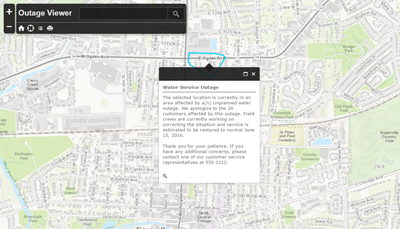
The Outage Viewer solution allows the public to enter their location and view any water service outages. This app is a configuration of ArcGIS Online and designed to be embedded on your utility's website.
The outage areas can be generated using one of the following processes:
- Saving the results from the Utility Isolation Trace web application.
- Using the Valve Isolation Trace tool part of the Water Geometric Network Editing and Analysis solution.
- Manually drawing in the outage areas.
Requirements
Outage Viewer requires specific technical experience and software.
| Requirement | Description |
| Software | Solution deployment
Solution hosting
|
| Applications |
|
| Companion Solutions |
What you get
When you deploy Outage Viewer, you'll find the following:
| Item | Name | Description |
| Application | Outage Viewer | An application used by the public to view water service outages. |
| Map | Outages | A map used in the Outage Viewer application to view water service outages. |
| Feature layer | Outage Details | A feature layer to store the location of water service outages. |
What's new
Below are the release dates and notes for Outage Viewer.
| Date | Description |
| November 2020 |
|
| March 2019 |
|
| June 2017 |
|
| January 2017 |
|
| June 2016 |
|
| August 2014 |
|