Overview
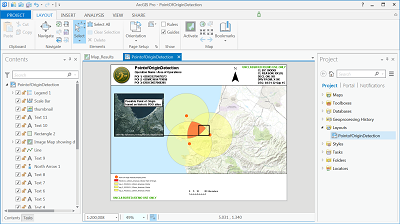
The Point of Origin Detection template is an ArcGIS Pro Project Template template that helps depict the areas where incoming indirect fires may have originated. This is accomplished by plotting the minimum and maximum effective ranges of a known enemy weapon system as concentric rings around the points of impact. The areas of intersection of these rings show the potential area of origin. Elevation and Terrain is not accounted for with this tool. This template will:
- Provide an example of a point of origin detection product.
- Provide tools and layers that can be used to determine possible point of origin areas.
- Provide notional sample data.
Requirements
Point of Origin Detection requires specific technical experience and software. Minimum system requirements for the ArcGIS Platform can be found on the Support website.
Point of Origin Detection is supported on ArcGIS 10.0, 10.1, 10.2 10.3 and ArcGIS Pro 1.1 and 1.2.
| Requirement | Description |
| Experience |
|
| Software |
Map Authoring
|
What you get
When you download the Point of Origin Detection template, the download includes the following:
| Folder | Item | Description |
| Maps | Map_Results | A map used to create the and view sample results and run Point of Origin. |
| Result_Inset_Image_Detail Map | A map used to create the inset map. | |
| Geodatabases | PointOfOriginDetection | A file geodatabases. Contains sample Weapons table, and sample points :Impact_pts_Monterrey_UTM10N" | SampleResults | A file geodatabases with sample results shown in help web page and used in the Layout |
| Results | A file geodatabase that can be used to store results from running the Template | |
| Layouts | PointOfOriginDetection | A layout for the Point Of Origin Detection results. |
| Tasks | Point Of Origin Detection | A set of preconfigured steps that guide you through the workflow of running the Geoprocessing script tool. |
What's new
Below are the release notes for Point of Origin Detection. If you need support, please contact Esri Support Services. If you'd like to get help from other military and intelligence community members, post your question on GeoNet.
| Version | Description |
| 5.0.1 | Support for ArcGIS Pro 1.2. |
| 5.0.0 | Support for ArcGIS Pro 1.1. |
| 4.0.0 | Support for ArcGIS 10.3. |
| 3.0.0 | Support for ArcGIS 10.2.2. |
| 2.0.0 | Support for ArcGIS 10.1 Service Pack 1. |
| 1.0.0 | Support for ArcGIS 10.0 Service Pack 2. |
You may be interested in
... related solutions that can be configured for your organization: