The Target Hazard Map utilizes two sources of input to conduct the analysis:
- Property information from the assessor's tax parcel data
- Hazard criteria from fire service personnel in the form of a spreadsheet
The TaxParcel feature class contains the polygons and attributes to be included in the TargetHazard feature class. The spreadsheet contains the hazard criteria and criticality values for each property. Each property is evaluated based on these two sources and a hazard score is calculated. The TargetHazard feature class has been populated with sample data and the Target Hazards layer symbolized by Total Hazard Score to demonstrate the final output.
Target Hazard Analysis is conducted in three stages:
- Load tax parcel data into the TargetHazard feature class.
- Populate the hazard criteria using the Target Hazard lookup spreadsheet.
- Summarize the hazard values and calculate the total hazard score.
Each stage is performed using the models and tools found in the Local Government toolbox inside the Target Hazard Mapping toolset.
Load parcel data into the TargetHazard feature class
The data in the TaxParcel feature class typically comes from the assessor's office. The parcel geometry and select attributes from this feature class must be loaded into the empty TargetHazard feature class with the necessary attributes, including values for the following:
- Use description
- Building area
- Number of floors
- Assessed value
To load data into the TargetHazard feature class, complete the following steps:
- Open the Load Hazard Parcel Data tool.
- Choose the Target Hazards layer for the Target Hazard parameter.
- Choose the Tax Parcels layer for the Tax Parcels parameter.
- If your parcel data is stored in the same schema as the TaxParcel feature class provided with the Local Government Information Model, the Field Map parameter should correctly align the necessary TargetHazard and TaxParcel fields. Otherwise, ensure that the following TargetHazard fields are correctly mapped to your tax parcels data:
PARCELID Parcel identifiers SITEADDRESS Site addresses (optional) USEDSCRP Use descriptions FLOORCOUNT Number of stories BLDGAREA Building areas CNTASSDVAL Assessed values 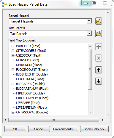
- Click OK.
When the tool has completed successfully, the TargetHazard feature class will be populated with the tax parcel information.
- Right-click the Target Hazards layer in the Table of Contents window and click Open Attribute Table. The following fields should now be populated with values from your tax parcel data:
- Parcel Identification Number
- Site Address
- Assessing Use Description
- Total Number of Floors
- Building Area Score
- Current Assessed Value