This item has been retired. Please see What's new for more information.

Overview

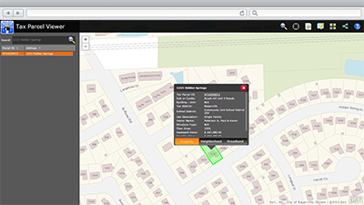
Tax Parcel Viewer is a configuration of ArcGIS and a JavaScript application that presents the general public property tax and assessment information and supplements that information with lifestyle and Internet broadband information for a given neighborhood. It is a single application that can be deployed by local governments and used by the general public on desktop computers, smartphones, or tablet devices.

The Tax Parcel Viewer offers a map-based view of tax parcel information that enables supporting agencies, organizations and the general public to locate an area of interest and review common information stored typically in a local government computer aided mass appraisal (CAMA) and tax receivables database. It provides a standard overview of property data in a community for consumers so they can view this information on all homes as they walk or drive through neighborhoods.

The application compliments the authoritative property characteristics with lifestyle and Internet broadband availability to give context to the individual interested in a given property. The broadband availability information comes from the National Broadband Map and reflects content collected during the National Broadband Inventory. Lifestyle information is provided by Esri Tapestry Segmentation. Esri Tapestry Segmentation classifies U.S. residential neighborhoods into 65 unique market segments based on socioeconomic and demographic characteristics and helps users understand the lifestyle and life stages of people residing in an area.

Requirements

Tax Parcel Viewer requires specific technical experience and software.

Requirement Description
Experience
  • Publishing GIS services
  • Authoring maps
  • Publishing applications using Microsoft Internet Information Services (IIS)
Software
Map authoring
  • ArcGIS for Desktop (Standard or Advanced)
    • ArcMap 10.2 - 10.4
GIS service hosting
  • ArcGIS Online, or
  • ArcGIS for Server 10.2 - 10.4 (Standard or Advanced)
    • ArcGIS Data Store, or
    • Enterprise or workgroup geodatabase
  • ReportLab 2.5 for Python 2.7 32-bit (reportlab-2.5.win32-py2.7.exe)
  • ReportLab 2.5 for Python 2.7 64-bit (reportlab-2.5.win-amd64-py2.7.exe)
Application hosting
  • Microsoft Internet Information Services (IIS) 7.0 or higher
  • Microsoft ASP.NET Framework 4.0 or 4.5
Browser compatibility

The application is optimized for display on desktop computer, tablet, and smartphone devices using the following browsers:

  • Microsoft Internet Explorer 10, 11
  • Mozilla Firefox
  • Google Chrome
  • Apple Safari

What you get

When you download the Tax Parcel Viewer, you'll find the following files:

Directory Item Description
Application TaxParcelViewer A folder containing the application files, graphics files, and items needed to configure the Tax Parcel Viewer application.
MIXED90CacheSettings.xml A tiling scheme suitable for the General Purpose and other basemaps.
MapsandGeodatabase AssessmentOperations.mxd A map document used to publish the AssessmentOperations service.
ParcelMarkups.mxd A map document used to publish the ParcelMarkups service.
GeneralPurpose.mxd A map document used to publish the General Purpose tiled or cached service.
ImageryReferenceOverlay.mxd A map document used to publish the Imagery Reference Overlay tiled or cached service.
TaxParcelQuery.mxd A map document used to publish the TaxParcelQuery service.
LocalGovernment.tbx A toolbox with tools used to configure the standard tax parcel reports.
LocalGovernment.gdb ArcGIS for Local Government geodatabase with content from the City of Naperville, Illinois.

What's new

Below are the release dates and notes for Tax Parcel Viewer.

Date Description
January 2017
  • This solution has been moved to mature support and replaced with a new Tax Parcel Viewer that leverages ArcGIS ArcGIS Web AppBuilder.
June 2016
  • Most recent LocalGovernment.gdb
February 2016
  • The most recent Local Government toolbox
July 2015
  • Most recent LocalGovernment.gdb
  • Most recent Local Government toolbox
December 2014
  • Support for ArcGIS API for JavaScript 3.11.
  • A resolution to a bug that prevented scrolling on iOS 8 devices.
  • Bit.ly shortlinks used in sharing options now supports oAuth authentication.
  • A resolution to a bug causing the zoom out and in buttons to be unresponsive on iOS 8 devices.
  • A resolution to a bug that prevented the informational pop-up tab from changing on iOS 8 devices (BUG-000082232).
  • A new set of maps with content for the City of Naperville, Illinois.
  • Most recent Local Government toolbox.
  • Most recent LocalGovernment.gdb.
June 2014
  • Most recent Local Government toolbox.
  • New sales, foreclosure, and assessment appeal symbology in the AssessmentOperations map document.
March 2014
  • Support for Android tablet browsers.
  • Most recent Local Government toolbox.
  • Pop-up fields now display currency less than one dollar correctly.
  • Pop-up fields have been reformatted and are now single spaced.
  • Removed a dependency on broadband and neighborhood maps that prevented the application from loading when the services were not available.
  • Added support for unique symbol classes in layer control.
  • Added support for more than three layers in layer control.
  • Resolved a bug that caused the same property report to be generated for all parcels (NIM094664).
10.2
  • Most recent LocalGovernment.gdb.
  • Support for ArcGIS API for JavaScript 3.5.
  • Search experience and autocomplete functionality has been improved.
  • User experience (icons, user interface, sharing) has been standardized across all ArcGIS for Local Government JavaScript applications.
  • Support for ArcGIS Online hosted services.
  • XML files have been added to support basemap caching schemas
  • Joins and relates have been removed from map documents to support ArcGIS Online hosted services
  • Removed hard-coded REST endpoint dependencies in the utils.js script (NIM088287).
  • A resolution to a bug causing the Create Property Map operation to generate a PDF that did not reflect the transparency seen in the browser (NIM088661).
  • A resolution to a bug causing the selected parcel to be off-center in the output PDF (NIM088662).
  • A resolution to a bug causing the selected parcel to be displayed in the output PDF at a hard-coded scale level instead of the currently visible display map (NIM088665).
  • An enhancement that changes the way the sharing option references parcels. The application now uses PARCELID instead of OBJECTID at the end of the URL to identify the selected property (NIM085131).
November 2012
  • The first release of the Tax Parcel Viewer.

Get started with Tax Parcel Viewer

You may be interested in

ArcGIS for Local Government includes several related maps and apps that also can be configured in your organization:

Top