The ArcGIS Solutions website will no longer be available after September 1, 2025. See the latest documentation.
This item has been retired. Please see What's new for more information.
Overview
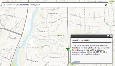
Sewer Service Lookup solution allows the public to view if sewer service is available for a chosen location. The app is designed to be embedded on the utility's website. The utility can optionally use this app as a marketing and customer service tool by capturing requests in the request tracking feature. For each location lookup a point will be created allowing the utility to view areas where people have inquired about sewer service.
Requirements
Sewer Service Lookup requires specific technical experience and software.
| Requirement | Description |
| Software |
Map authoring
Map Service Hosting
|
| Applications |
|
What you get
When you download Sewer Service Lookup, you'll find the following in the zip file:
| Directory | Item | Description |
| Maps and GDBs | SewerServiceArea.mxd | A map document used to publish the Service Area service. |
| SewerServiceRequestTracking.mxd | A map document used to publish the optional Request Tracking service. | |
| SewerServiceLookup.gdb | A sample geodatabase with the service area and request tracking schema. | |
| Icons | A folder containing icons for the services, maps, and apps. | |
What's new
Below are the release dates and notes for Sewer Service Lookup.
| Date | Description |
| November 2020 |
|
| December 2019 |
|
| January 2017 |
|
| January 2014 |
|