The ArcGIS Solutions website will no longer be available after September 1, 2025. See the latest documentation.
This item has been moved to mature support. Please see What's new for more information.
Overview
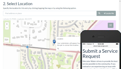
Water Service Request is a configuration of the ArcGIS GeoForm web application template that can be used by citizens to report issues with water, sewer, and stormwater service or infrastructure. This application allows the public to complete the service request form and submit the location of the issue. New service requests can then be used by a utility to investigate the situation and create any necessary workorders.
Requirements
Water Service Request requires specific technical experience and software.
| Requirement | Description |
| Software | Solution deployment
Solution hosting
|
| Applications |
|
What you get
When you deploy Water Service Request, you'll find the following:
| Item | Name | Description |
| Application | Water Service Request | An application used by the public to submit issues with water, sewer, or stormwater systems. |
| Map | Water Service Request | A map used by the public to record water utility service issues. |
| Feature layer | Water Service Request | A feature layer used to store the location of water utility service issues. |
What's new
Below are the release dates and notes for Water Service Request.
| Date | Description |
| June 2020 |
|
| June 2017 |
|
| January 2017 |
|
| July 2015 |
|
| February 2015 |
|
You may be interested in