Overview
Shelter Locator can be used by emergency management agencies responsible for providing citizens a safe place when they are displaced from their residence during a natural or man-made incident. Emergency shelter status and shelter-specific information (capacity, current occupancy, special needs, etc.) is often provided and managed by Incident Management Systems like WebEOC from Intermedix.
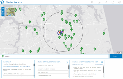
Shelter Locator is a configuration of ArcGIS, and optionally WebEOC, that allows citizens to locate emergency shelters in their community from a smartphone, tablet, and desktop computer.
Requirements
Shelter Locator requires specific software.
| Requirement | Description |
| Software | Map authoring
GIS service hosting
Application hosting
|
| Browser compatibility | The application is optimized for display on desktop computer, tablet, and smartphone devices using the following browsers:
|
What you get
When you download the Shelter Locator application, the download includes the following:
| Directory | Item | Description |
| Application | ShelterLocator | A folder containing the Shelter Locator application files. |
| MapsandGeodatabase | Shelters.mxd | A map document used to publish the Shelters service. |
| EmergencyManagement.gdb | Emergency Management geodatabase with sample data. |
What's new
Below are the release dates and notes for Shelter Locator.
| Date | Description |
| December 2017 |
|
| January 2017 |
|
| September 2016 |
|
| June 2016 |
|
| February 2016 |
|
| August 2015 |
|
You may be interested in
ArcGIS Solutions for Emergency Management includes several related maps and apps that also can be configured in your organization: