Overview
Capital Project Planning is a configuration of ArcGIS that can be used by local government staff to define and coordinate capital projects, engage external agencies, and share your capital improvement plan. Capital projects are typically defined for water, sewer, stormwater, and transportation assets in a community; and used to maintain, improve, and/or enhance public assets.
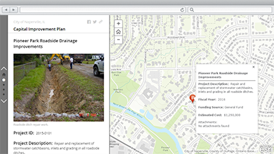
Individual capital projects are scoped by engineers, reviewed by local government staff, and organized in to a Capital Improvement Plan (CIP). The CIP is a short range plan that identifies capital infrastructure projects in need of renovation, repair, and/or construction. The CIP relates these projected capital needs to the financial resources necessary to support their completion and the timeframe in which both the financing and work will take place.
Capital Project Planning works with Capital Project Tracking to provide a comprehensive capital projects solution that can be used to define capital projects, coordinate project schedules, track project performance, and share project status with key stakeholders and the general public.
Requirements
Capital Project Planning requires specific software.
| Requirement | Description |
| Software |
Map authoring
GIS service hosting
|
| Applications |
|
What you get
Capital Project Planning is a configuration of Basic Viewer, ArcGIS Web AppBuilder, and Story Map Journal applications and can be configured in ArcGIS Online without downloading any applications. However, if you want to host the applications on your own server the applications are available to download from GitHub.
What's new
Below are the release dates and notes for Capital Project Planning.
| Date | Description |
| December 2017 |
|
| September 2016 |
|
| June 2016 |
|
| July 2015 |
|
You may be interested in
ArcGIS for Local Government includes several related maps and apps that also can be configured in your organization:
Additional information
Learn more about the unique capabilities in this solution and the business value it provides an organization.