Overview
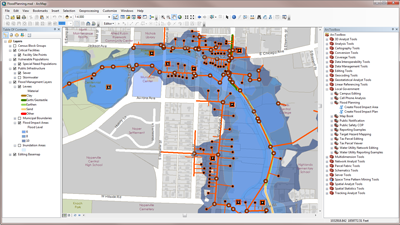
Flood Planning is used by mapping technicians in public safety, emergency management, public works, or planning agencies to analyze the impact of seasonal flooding scenarios and develop flood response plans. Flood Planning allows you to analyze the impact of flooding for multiple flood levels and create a flood impact plan for each flood level. It also allows you to develop preliminary levee plans and budget estimates for each levee.
The flood impact analysis identifies public infrastructure, critical facilities, and vulnerable residents that may be impacted. This information will help you develop a plan to mitigate the impact on the community, and budget for the cost of proposed levees that may be necessary.
Requirements
Flood Planning requires specific software.
| Requirement | Description |
| Software |
Map authoring
|
What you get
When you download the Flood Planning map, the download includes the following:
| Directory | Item | Description |
| Application | AttributeAssistant.esriAddIn | An ArcMap Add-in that includes the Attribute Assistant toolbar and a series of predefined methods to automatically populate attributes (for example, validate road names from master street name table) when features are created and updated. |
| MapsandGeodatabase | FloodPlanning.mxd | A map document used to analyze the impact of seasonal flooding and develop response plans. |
| LocalGovernment.tbx | A toolbox with tools for identifying flood impact areas and vulnerable infrastructure, facilities, and populations. | |
| LocalGovernment.gdb | ArcGIS for Local Government geodatabase with content from the City of Naperville, Illinois. |
What's new
Below are the release dates and notes for Flood Planning.
| Date | Description |
| February 2020 |
|
| March 2019 |
|
| January 2018 |
|
| March 2017 |
|
| July 2016 |
|
| June 2016 |
|
| February 2016 |
|
| July 2015 |
|
| December 2014 |
|
| June 2014 |
|
| December 2013 |
|
There is a newer version...
Flood Planning (ArcMap) has been moved to mature support and replaced with Flood Impact Analysis (ArcGIS Pro).