Overview
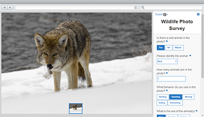
Wildlife Photo Survey can be used to publish photos collected from camera traps and conduct surveys that may identify animals in their natural habitat.
Wildlife Photo Survey leverages location-enabled photos produced by many commercially available camera traps used in the wild and simplifies data processing so photo collections can be gathered on a regular basis. It combines photos with a series of questions and enables fish and wildlife staff, or the general public, to review captured images and quickly gather information about the distribution and behavior of wild animals in their natural habitat.
Requirements
Wildlife Photo Survey requires specific software.
| Requirement | Description |
| Software |
Map authoring
GIS service hosting
Application hosting
|
| Browser compatibility |
The application is optimized for display on desktop computer, tablet, and smartphone devices using the following browsers:
|
What you get
When you download Wildlife Photo Survey, you'll find the following files:
| Directory | Item | Description |
| Application | PhotoSurvey | A folder containing the Wildlife Photo Survey application files. |
| SurveyConfigurations | A folder containing sample property survey questions. | |
| PhotoSurvey.tbx | A toolbox with a tool used to import photo collections and publish property surveys. |
What's new
Below are the release dates and notes for Wildlife Photo Survey.
| Date | Description |
| March 2023 |
|
| June 2019 |
|
| January 2019 |
|
| December 2017 |
|
| June 2016 |
|