Overview
ArcGIS Online or Portal for ArcGIS is a mapping platform for organizations that can be used from anywhere on any device, web browser, or desktop application. Organizations can subscribe to this secure platform and use it to manage, create, store, and access hosted services, maps and applications.
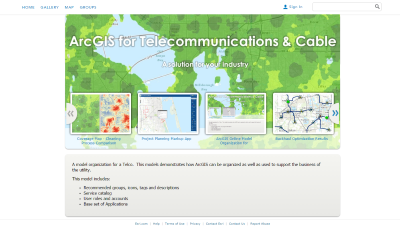
The Model Organization for Wireline and Cable is used by organizations to access dynamic, authoritative content to create, collaborate, catalog, and share maps, data, and applications with members of your organization or the general public.
Requirements
Model Organization for Wireline and Cable requires specific technical experience and software.
| Requirement | Description |
| Software |
|
What you get
When you download the Model Organization for Wireline and Cable, you'll find the following files:
| Directory | Item | Description |
| GraphicTemplates | BannerTemplate.ppt | A Microsoft PowerPoint document used to create an ArcGIS home page banner. |
| ThumbnailTemplate.ppt | A Microsoft PowerPoint document used to create icons for each ArcGIS item. | |
| InitializeOrganization | A set of Python 2.7 scripts to create and update the required services, maps, and apps in your organization. These scripts utilize the Automated Setup & Reporting tools. | |
What's new
Below are the release notes for the Model Organization for Wireline and Cable.
| Date | Description |
| December 2018 |
|
| April 2016 |
|
| February 2016 |
|
| August 2015 |
|
Known issues
- The StageOrg.py is unable to register Esri's ArcGIS Online content with Portal for ArcGIS