Overview
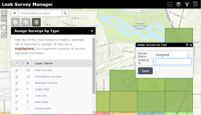
The Leak Survey Manager allows operation managers to view the progress of leak surveys and assign new work using a configuration of the Web AppBuilder for ArcGIS.
This app provides managers with reporting layers that summarize leak surveys by area, leak survey types by due date, and a set of tools to create and assign leak survey assignments.
This solution also includes Python scripts using the Automated Setup & Reporting tools to calculate the following:
- Asset count (footage of mains and number of services) for leak survey grids
- Asset count for township overview area
- Leak survey report for township overviews area
Requirements
Leak Survey Manager requires specific technical experience and software.
Requirement |
Description |
Software |
Data Publishing
- ArcMap (Standard or Advanced) 10.2.1, 10.5 - 10.8
- Python 2.7.x
Map Authoring
- ArcMap (Standard or Advanced) 10.2.1, 10.5 - 10.8
- ArcGIS Online
- ArcGIS Enterprise 10.5 - 10.8
Map service hosting
- ArcGIS Enterprise 10.5 - 10.8 (Standard or Advanced)
Application hosting
- ArcGIS Online
- ArcGIS Enterprise 10.5 - 10.8
|
Prerequisites |
|
What you get
When you download Leak Survey Manager, you'll find the following in the zip file:
Directory |
Item |
Description |
Application |
Reporting Tools |
A folder containing the Python 2.7 scripts to perform the summarization of the asset and leak survey data. These scripts utilize the Automated Setup & Reporting tools. |
Maps and GDBs
|
LeakSurvey.gdb
|
A sample geodatabase with the leak survey schema and sample data.
|
NapervilleGas.gdb |
A sample geodatabase gas network and leak survey data. |
LeakSurvey.sde |
A sample enterprise or workgroup database connection. |
LeakSurvey.tbx |
A toolbox with tools used for the post-processing of leak survey data. |
GasLeaks.mxd
|
A map document used to publish the gas leak service.
|
LeakSurveyAssignments.mxd |
A map document used to publish the editable leak survey assignment areas service. |
LeakSurveyReports.mxd |
A map document used to publish the leak survey assignment reports service. |
LeakSurveyType.mxd |
A map document used to publish the non-editable leak survey assignment areas service. This service is used to view assignments by due date. |
Icons |
A folder containing icons for the services, maps, and apps. |
What's new
Below are the release dates and notes for Leak Survey Manager.
Date |
Description |
November 2020 |
- Leak Survey Manager has been moved to Mature Support.
|
June 2017 |
- An update to the Leak Survey Reports map document to remove the database specific data frames and symbolize areas with no overdue surveys.
- Most recent version of the Automated Setup & Reporting tools that include the following:
- A resolution to a bug in which using a custom length field in the report summary would result in incorrect results. When reporting on a custom length field, values can now be proportionally split when setting the new reclass report parameter, AdjustCountField, to true (BUG-000100918).
- A new parameter in the reclass report configuration, ReportAreasOverlap, which reports when a feature is split and the sum of the parts do not equal the original feature length. The logic is similar to the Pairwise Intersect tool, which results in faster processing.
- A new parameter in the reclass report configuration, ReclassType, which determines how features that span multiple reporting areas will be summarized.
|
February 2016 |
|
November 2015 |
- Removal of the Batch Attribute Editor widget from the download; widget is now part of Web AppBuilder
- Use of Web AppBuilder (Developer Edition) no longer required
|
August 2015 |
- Batch Attribute Editor upgraded to Web AppBuilder (Developer Edition) 1.2
-
Latest versions of the ArcREST tools
- Config file enhancements
|
July 2015 |
- Leak Survey Python scripts that utilize the Automated Setup & Reporting tools
- Revised set of map documents to support the updated solution
- LeakSurvey.tbx with a model to reset the leak survey assignments
- Use of the Batch Attribute Editor widget to assign the survey areas
- Schema changes including the removal of the work order feature class, merged leak survey grid layer, historical leak survey grid and GPS log feature classes
|
March 2015 |
- Updates to the Leak Survey Python scripts:
- Remove update township overview layer from Leak Survey Grid Updates
- Clear geoprocessing workspace when script is completed
- Various bug fixes
|
December 2014 |
- Configuration of the manager viewer using Web AppBuilder for ArcGIS
- Schema update to the leak survey grid layers to include the "Workorder Type" and "Grid Survey Type" fields
- Schema update to the workorder layer to include the "Grid Survey Type" field
- Latest versions of the ArcREST and ArcREST Helper tools
-
Configuration files schema changes
-
FeatureService section to FeatureServices
-
Login info only defined in the GlobalLoginInfo file
- EnableEditTracking parameter added to FeatureServices section
- UpdateItemContent changes to UpdateService in MapDetails
- Portal in login section changed to Orgurl
- ExistingService change to ExistingServices
- ExistingServices ReportResult tag changes to FeatureClass
- ReplaceTag added to section
- ReplaceInfo Section now uses the following three parameters, SearchString, ReplaceString and ReplaceType
- Updated configuration files to support the Utility and Pipeline Data Model
|
August 2014 |
- Ability to handle multiple survey types in a single map grid
|
June 2014 |
- First release of Leak Survey Manager
|