This item has been moved to mature support. Please see What's new for more information.
Overview
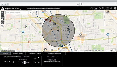
Logistics Planning is a configuration of ArcGIS Web AppBuilder that can be used by emergency management personnel to plan logistical operations and manage resource requests during an incident or event.
Logistics Planning can include incident and operation response information as part of a suite of applications to maintain situation awareness and provide a common operational picture.
Requirements
To deploy Logistics Planning with the ArcGIS Solutions Deployment Tool requires specific software.
| Requirement | Description |
| Software |
Solution deployment
Solution hosting
|
| Application |
|
What you get
Logistics Planning can be deployed in your ArcGIS organization without downloading the solution. When you deploy Logistics Planning in your organization, you'll find the following:
| Directory | Item | Description |
| Application | Logistics Planning | An application used by emergency management personnel to plan logistical operations and manage resource requests during an incident or event. |
| Map | Logistics Planning | A map used to display information about logistical operations and resource requests during an incident or event. |
| Feature layers | CommodityStaging | A feature layer used store commodity staging locations. |
| CommodityStaging_active | A feature layer view used manage active commodity staging locations. | |
| Evacuations | A feature layer used to store evacuation routes, areas, and their status. | |
| Evacuations_active | A feature layer view used to manage active evacuation routes, areas, and their status. | |
| IncidentLocations | A feature layer used to store incident locations and related information. | |
| IncidentLocations_active | A feature layer view used to manage active incident locations and related information. | |
| MissionReadyPackages | A feature layer used to store locations where specific response and recovery capabilities are deployed during an incident. | |
| MissionReadyPackages_active_dashboard | A feature layer view used to view active locations where specific response and recovery capabilities are deployed during an incident. | |
| PointsofDistribution | A feature layer used to store locations where the public goes to pick up emergency supplies following an incident. | |
| PointsofDistribution_active | A feature layer view used to manage active locations where the public goes to pick up emergency supplies following an incident. | |
| ResponseFacilities | A feature layer used to store locations where specific facilities, assets, and resources and placed during an incident. | |
| ResponseFacilities_active_dashboard | A feature layer view used to view active locations where specific facilities, assets, and resources and placed during an incident. | |
| RoadClosures | A feature layer used to store current and planned road blocks, road closures with location affected, and detour routes. | |
| RoadClosures_active | A feature layer view used to manage active, current road blocks, road closures with location affected, and detour routes. | |
| Living Atlas layers | World Traffic Service | A Living Atlas map service map service presents historical and near real-time traffic information for different regions in the world. |
What's new
Below are the release dates and notes for Logistics Planning.
| Date | Description |
| November 2020 |
|
| June 2019 |
|
| January 2019 |
|
| June 2018 |
|
| April 2018 |
|
| December 2017 |
|
| June 2017 |
|
| March 2017 |
|
| January 2017 |
|
| December 2016 |
|
| September 2016 |
|
| June 2016 |
|
| December 2015 |
|
| November 2015 |
|
| October 2015 |
|