The Photo Survey application consumes maps that are publicly accessible through your ArcGIS Online organization. Create a Photo Survey map and share it with the general public so they can access the Photo Survey application on smartphones, tablets, and desktop computers.
Photo Survey map
To create an ArcGIS Online Photo Survey map, complete the following steps:
- Sign in to your ArcGIS Online organization.
-
Create a map to display photos for properties, by completing the following workflow:
- Choose a basemap.
- Add the PhotoSurvey layer to the map.
-
Configure pop-up for the PhotoSurvey layer using the custom attribute display option.
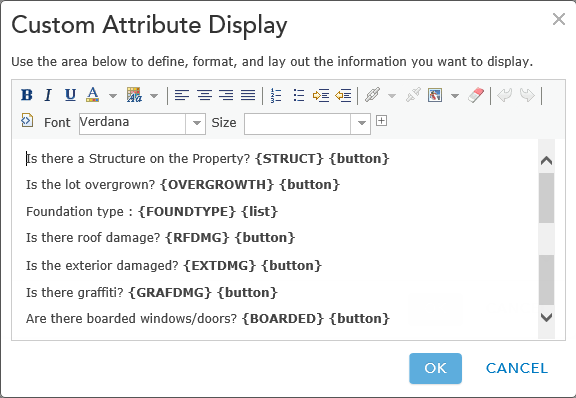
An example of a pop-up configuration -
Save the map and type in a name and the following tags:
- Tags: Photo Survey, Property Survey, Photo Collection, Street-Level Photos, Condition Survey
- Share the map with everyone.
-
Browse to the map and edit the item details:
- Title: your map name.
- Thumbnail image: A high resolution image for your Photo Survey application that will appear on the application login screen.
- Summary: Summary information for your Photo Survey application that will appear on the application login screen.
- Description: Help information for your Photo Survey application that will appear on the application help page.
-
Access and Use Constraints: User contribution levels for your Photo Survey application that will appear on the application user profile page.
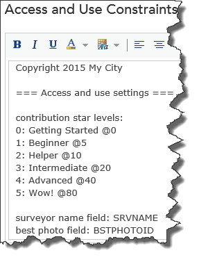
An example of the contribution settings within the map Copyright 2015 My City === Access and use settings === contribution star levels: 0: Getting Started @0 1: Beginner @5 2: Helper @10 3: Intermediate @20 4: Advanced @40 5: Wow! @80 surveyor name field: SRVNAME best photo field: BSTPHOTOID