This item has been moved to mature support. Please see What's new for more information.

Overview

Water Trace Overview

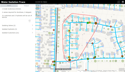
The Utility Isolation Trace app allows the operator to specify a location, such as a main break, and determine which valves to close and what hydrants and customers will be out of service.

This solution uses a custom widget in Web AppBuilder for ArcGIS to run the isolation trace. To determine the isolation area, information is passed to a geoprocessing service to run the analysis and process the results. The results are returned to the app, where a valve can be skipped and the process re-ran. When the isolation area has been verified, the results can be saved to the Outage Details feature service. This service can be used to power additional maps and apps at your water utility, such as a public Outage Viewer.

Note: This app only finds the closest valves and does not evaluate whether there are dead ended segments. If you are looking for advanced isolation logic, use the isolation trace tools that are part of the Water Geometric Network Editing and Analysis solution.

Requirements

Utility Isolation Trace requires specific technical experience and software.

Requirement Description
Software
Map authoring
  • ArcMap (Standard or Advanced) 10.2.1, 10.4 - 10.6
  • ArcGIS Pro (Standard or Advanced) 2.1 - 2.3
  • ArcGIS Online, or
  • ArcGIS Enterprise 10.5 - 10.6.1, or
  • Portal for ArcGIS 10.4
Geoprocessing server
  • ArcGIS Enterprise (Standard or Advanced) 10.5 - 10.6.1, or
  • ArcGIS for Server (Standard or Advanced) 10.4
Map service hosting
  • ArcGIS Online, or
  • ArcGIS Enterprise (Standard or Advanced) 10.5 - 10.6.1, or
  • ArcGIS for Server (Standard or Advanced) 10.4
    • Portal for ArcGIS
Application hosting
  • ArcGIS Enterprise 10.5 - 10.6.1, or
  • Portal for ArcGIS
  • Microsoft Internet Information Services (IIS) 7.0 or higher
  • Microsoft ASP.NET Framework 4.0 or 4.5
Applications
  • Web AppBuilder for ArcGIS (Developer Edition)
Prerequisites

What you get

When you download the Utility Isolation Trace application, you'll find the following in the zip file:

Directory Item Description
Application NetworkTrace A Web AppBuilder widget that can be configured to run the isolation trace.
Maps and GDBs IsolationTrace.mxd A map document used to publish the IsolationTrace geoprocessing service.
WaterDistributionNetwork.gdb A sample geodatabase with water network data from the City of Naperville, Illinois.
PublicationGDB.tbx The toolbox with tools used to create the publication geodatabase from your enterprise database.
GenerateTool.pyt A Python toolbox used to generate the IsolationTrace toolbox for publishing to ArcGIS Enterprise.
GenerateTool.pyt.xml The metadata for the GenerateTool.pyt toolbox.
GenerateTool.GenerateIsolationTraceToolbox.pyt.xml The metadata for the GenerateIsolationTraceToolbox tool.
ToolData The data required to generate the IsolationTrace toolbox from the GenerateIsolationTraceToolbox tool.
Icons A folder containing icons for the services, maps, and apps.

What's new

Below are the release dates and notes for Utility Isolation Trace.

Date Description
March 2019
February 2018
  • A resolution to a bug in which the Save To Layer check box was not correctly being set in the configuration page.
  • A resolution to a CSS issue that removed padding from the widget frame.
January 2018
  • A resolution to an issue in which when using Internet Explorer the saved CSV from the widget would automatically open. You are now prompted to either save, open, or cancel the request when using Internet Explorer.
  • A resolution to an issue in which CSS values in the Network Trace widget were hard coded.
June 2017
  • A redesign of the Isolation Trace process to simplify the configuration and publishing of the service. This update includes the GenerateIsolationTraceToolbox tool in the GenerateTool.pyt that uses the configuration parameters you specify to generate the IsolationTrace tool that will be used for publishing to ArcGIS Enterprise.
  • An update to the wAbandonedPoint and wAbandonedLine layers in the WaterUtilityNetwork.gdb. The POINTTYPE and LINETYPE fields were renamed to ABANSOURCE. The LINETYPE field was also used in the wLateralLine class and the value in this field would be overwritten by the layer name when a feature was abandoned using the Abandon tools in the Water Geometric Network Editing and Analysis solution.
July 2016
  • A resolution to a bug with the Publication GDB script that deleted data in the source geodatabase.
June 2016
  • A series of enhancements to the IsolationTrace geoprocessing model that include the following:
    • Common ID created and added to each result. This allows for all results of a trace to share a unique trace identifier field.
    • Common ID added as a return parameter. This allows for the trace identifier to be applied to an outage area in the Network Trace widget.
    • Isolated Mains and laterals are returned in the output.
  • The inclusion of the PublicationGDB.tbx to create a new publication geodatabase and prepare water network data in the Local Government Information Model schema for use in the Utility Isolation Trace application.
  • The WaterWebIsolation.gdb has been replaced with LocalGovernment.gdb.
  • The removal of the OutageDetails.mxd. This schema is now included as part of the Outage Viewer.
  • The latest version of the Network Trace widget, which includes support for Web AppBuilder (Developer Edition) 2.0.
February 2016
  • The latest version of the Network Trace widget, which includes support for Web AppBuilder (Developer Edition) 1.3.
October 2015
  • The latest version of the Network Trace widget, which includes user interface updates and support for Web AppBuilder (Developer Edition) 1.2.
  • Resolved issue in sample dataset.
August 2015
  • Support for standard license by using "Feature Class to Feature Class" versus "Feature to Point"
July 2015
  • The most recent sample network data from the Local Government Information Model
  • A resolution to a bug caused by projection issues (BUG-000086733); IsolationTrace geoprocessing model now handles projections and empty feature sets
  • The use of Web AppBuilder and the Network Trace widget instead of the custom JavaScript application
June 2014
  • New outage schema
  • Ability to save outage details
  • Additional application updates
January 2014
  • First release of Utility Isolation Trace

Known Issues

  • In the Utility Isolation Trace, all valves are used to stop the trace. If your hydrant and lateral valves are in the same layer as the system valves, these features need to be removed from the system valves layer. The PublicationGDB.tbx is provided to streamline this process.
  • The Trace Geometric Network Find Connected task used as part of the IsolationTrace model requires that the mains be split at the disabling layer (system valves) locations. The PublicationGDB.tbx is provided to streamline this process.
  • PostgreSQL is not a supported data source for the PublicationGDB script.
  • To accurately place a flag on the main, the process snaps the flags and barriers to the lines. This snap process fails to create the correct location on lines that are composed of true curves. Data should be densified prior to publishing. Alternatively, you can use vertex snapping to ensure a flag or barrier is properly set.

Get started with Utility Isolation Trace

Top