The ArcGIS Solutions website will no longer be available after September 1, 2025. See the latest documentation.
This item has been moved to mature support. Please see What's new for more information.
Overview
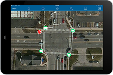
Sign Inventory can be used to inventory traffic signs erected at the side of, or above roads.
The Sign Inventory map helps transportation staff develop a comprehensive inventory of signs and the poles to which they are attached, and prepares this information for related maintenance management workflows.
Requirements
To deploy Sign Inventory with the ArcGIS Solutions Deployment Tool requires specific software.
| Requirement | Description |
| Software |
Solution deployment
Solution hosting
|
| Applications |
|
To manually deploy Sign Inventory in your organization requires specific software.
| Requirement | Description |
| Software | Map authoring
GIS service hosting
|
| Applications |
|
What you get
Sign Inventory can be deployed in your ArcGIS organization without downloading the solution. When you deploy Sign Inventory in your organization, you'll find the following:
| Item | Name | Description |
| Map | Sign Inventory | A map used by field staff to inventory traffic signs erected at the side of, or above roads. |
| Feature layers | Poles | A feature layer used to store poles erected at intersections or along the side of roads and where signs, lights and signals are typically mounted. |
| Signs | A feature layer used to store signs erected at the side of roads to provide information to road users. |
What's new
Below are the release dates and notes for Sign Inventory.
| Date | Description |
| November 2023 |
|
| March 2019 |
|
| January 2018 |
|
| March 2017 |
|
| January 2017 |
|
| September 2016 |
|
| July 2016 |
|
| June 2016 |
|
| July 2015 |
|