In order to create the output voice coverage layer, the input signal strength raster is processed by a series of geoprocessing tools and models. The output from each of these tools and models is intermediate and overwritten during an iterative process where the output from a series of steps becomes the new input. To better understand what each process is performing, the major geoprocessing tools and models are explained, with the output shown for a sample area:
-
The input raster (cell values ranging from -100 to 52) is reclassified by three different power levels: -70, -80, and -90 (represented by the colors red, green, and blue, respectively). Each image is then filtered to remove noise.
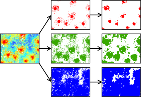
Shown is the input signal strength raster, result from Reclassify, and result from Majority Filter + Boundary Clean. Note the blue-colored values in the input signal strength raster (values -90 to -100) are not included as they are outside the threshold. -
Resampling further simplifies the rasters. The three rasters are then mosaicked together with the maximum operator.
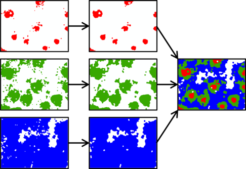
Shown is the result from Majority Filter + Boundary Clean, result from Resample + Majority Filter, and result from Mosaic to New Raster. Note how further filtering and resampling removes noise from each raster. -
After Raster to Polygon is executed, small features, holes, and gaps remain.
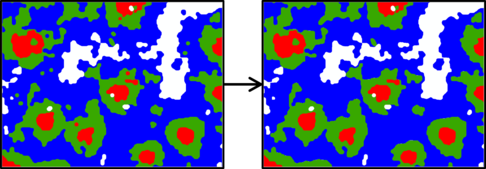
Shown is the input vector and result from Delete on areas less than 500,000 square meters. Note the small green and red features are being merged with surrounding, larger polygons. -
Once small features have been merged with neighboring polygons, holes and gaps are filled in.
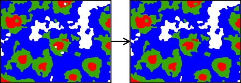
Shown is the result from Eliminate Polygon Part and the result from 2.2 Eliminate Gap. Note that in the first image, polygon holes are being filled in while the second image showcases the filled in gaps.