The Gas Utility Editing toolbar is a series of tools to improve a map technician's editing infrastructure data experience.
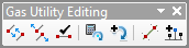
| Tool | Tool Name | Description |
 |
Connect Geometric Network Features | Connect selected features participating in a geometric network. |
 |
Disconnect Geometric Network Features | Disconnect selected features participating in a geometric network. |
 |
Connection Checker | Evaluate the geometric network features in the visible extent to verify
|
 |
Rotate Selected Junctions | Rotate select point features to match the orientation of a connecting line. Customize the rotation in the configuration file. |
 |
Add Rotation to Feature | Add a predefined value to the rotation of selected point features. You can customize the rotation in the configuration file. |
 |
Split Lines at Selected Points | Split line features where they intersect selected point features. An elevation field can be provided as a parameter. You can set the snap distance, the smallest line to skip, and turn off the Attribute Assistant before the split in the configuration file. |
 |
Add Laterals at Connections | Evaluate selected point features and draw a line (lateral) from each point to the closest feature in the specified line (mains) layer. Additional point features can be placed along the line (lateral). Only point layers defined in the configuration file are evaluated with this tool. To override the defined edit templates, press and hold the CTRL key before pressing this button. To search for the closest selected main, press and hold the SHIFT key before pressing this button. |