Capital Project Tracking leverages capital project information created in Capital Project Planning. It helps local government staff track project performance and share project status with key stakeholders and the general public. The following maps must be configured to track and share the schedule, quality, and cost of capital projects in your community:
If your organization uses a third-party project management or accounting system to track project performance, you do not need to create the project tracking maps. Instead, export project information from your third-party project management or accounting system and combine this information with your capital project layer. Then, add it to your ArcGIS organization prior to configuring the project dashboard and project status maps.
Project Journal maps
Project Journal maps are used by engineers and project managers to record comments during capital project construction.
To create the ArcGIS Online Project Journal maps for water, sewer, stormwater, and transportation assets, complete the following steps:
- Sign in to your ArcGIS Online organization.
- Create a map to record comments during capital project construction, by completing the following workflows:
- Choose a basemap.
- Add the InfrastructureProjects layer and Project Comments table to the map and rename the InfrastructureProjects layer to Water Distribution Projects.
- Configure pop-up for the Water Distribution Projects layer and Project Comments table using the list of field attributes option.
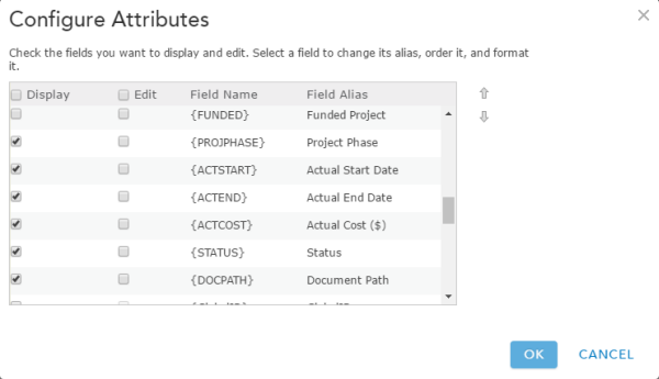
An example of a pop-up configuration - Save the map as Water Distribution Project Journal, then type in tags that describe your map and enter a summary.
- Apply a filter to the Water Distribution Projects layer, by using the following expressions : Project Type Is Water Distribution and Project Status Is Board Authorized.
- Save the map and share it with your Public Works Services group.
- Browse to the Water Distribution Project Journal map and edit the item details.
- Repeat steps 2 through 5 above for each asset you'd like to track construction activity on.
Project Tracking maps
Project Journal maps are used by engineers and project managers to communicate the schedule, cost, and quality of active infrastructure projects to executives in the organization.
To create the ArcGIS Online Project Tracking maps for water, sewer, stormwater, and transportation assets, complete the following steps:
- Sign in to your ArcGIS Online organization.
- Create a map to track the schedule, quality, and cost of water, sewer, stormwater, and transportation projects, by completing the following workflows:
- Choose a basemap.
- Add the InfrastructureProjects layer and ProjectComments table to the map and rename the InfrastructureProjects layer to Water Distribution Projects.
- Configure pop-up for the Water Distribution Projects layer Project Comments table using the list of field attributes option.
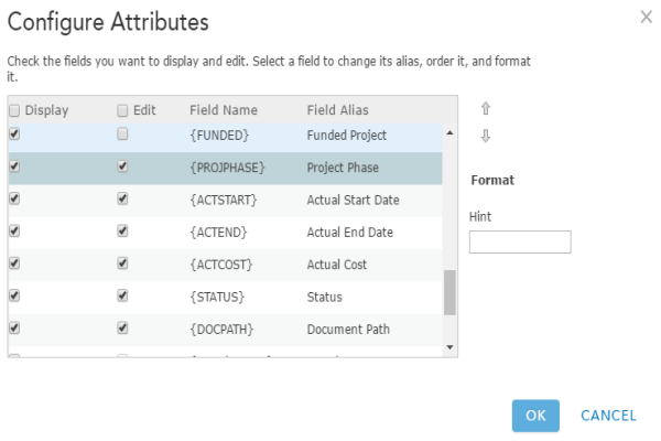
An example of a pop-up configuration - Save the map as Water Distribution Projects, then type in tags that describe your map and enter a summary.
- Apply a filter to the Water Distribution Projects layer, by using the following expressions : Project Type Is Water Distribution and Project Status Is Board Authorized.
- Save the map and share it with your Capital Project Tracking group.
- Browse to the Water Distribution Projects map and edit the item details.
- Repeat steps 2 through 4 above for each asset you'd like to track construction activity on.
Project Dashboard map
The Project Dashboard map is used by executives to monitor the status of capital projects.
To create an ArcGIS Online Project Dashboard map, complete the following steps:
- Sign in to your ArcGIS Online organization.
- Create a map to monitor the schedule, quality, and cost of water, sewer, stormwater, and transportation projects, by completing the following workflows:
- Choose a basemap.
- Add the InfrastructureProjects layer to the map and rename it to Current Capital Projects.
- Configure pop-up for the Current Capital Projects layer using the list of field attributes option.
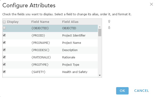
An example of a pop-up configuration - Save the map as Capital Projects - Executive Dashboard, then type in tags that describe your map and enter a summary.
- Apply a filter to the Current Capital Projects layer, by using the following expression: Project Status Is Board Authorized.
- Disable editing on the Current Capital Projects layer.
- Set the refresh interval to 5 minutes on the Current Capital Projects layer.
- Save the map and share it with your Public Works Services group.
- Browse to the Capital Projects - Executive Dashboard map and edit the item details.
Capital Projects map
Before you create a capital projects map to share status with key stakeholders and the general public, create a secure InfrastructureProjects service for the public. Embed the credentials in the new item so the public is not required to sign in to see the status of capital projects in your community. You may also want to limit usage to control how many times, and by whom, the InfrastructureProjects service is accessed.
Secure services
To create a secure InfrastructureProjects service, complete the following steps:
- Sign in to your ArcGIS Online organization.
- Add InfrastructureProjects service from the web as a secure services used by your ArcGIS organization using the following parameters:
- Type: ArcGIS Server web service.
- URL: http://services.arcgis.com/ID/arcgis/rest/services/InfrastructureProjects/FeatureServer/4.
- Username/Password: your user name and password. Choose to Store credentials with service item. Do not prompt for authentication.
- Title: PublicInfrastructureProjects.
- Tags: Public Works, Capital Planning, CIP, Capital Improvement Plan, Capital Projects, Project Planning, Water, Sewer, Stormwater, Transportation.
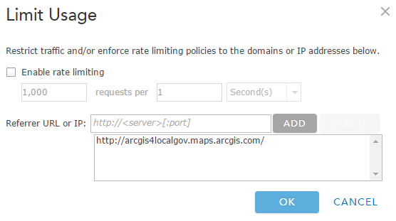
- Limit usage of the InfrastructureProjects service used by your ArcGIS organization.
- Browse to the PublicInfrastructureProjects service you just secured and edit the item details:
- Thumbnail image: Your image.
- Description: A secure InfrastructureProjects service used in applications shared with the general public.
- Share the service with everyone and your Public Works Services group.
Create map
The Capital Projects map is used to share the status of capital projects with key stakeholders and the general public.
To create an ArcGIS Online Capital Projects map, complete the following steps:
- Create a map to share the status of water, sewer, stormwater, and transportation projects with interested parties, by completing the following workflows:
- Choose a basemap.
- Add the PublicInfrastructureProjects layer to the map.
- Configure the pop-up for the PublicInfrastructureProjects layer.
- Save the map as Capital Projects, then type in tags that describe your map and enter a summary.
- Apply a filter to the PublicInfrastructureProjects layer, by using the following expression: Project Status Is Board Authorized.
- Disable editing on the PublicInfrastructureProjects layer.
- Save the map and share it with everyone and your Public Works Services group.
- Browse to the Capital Projects map and edit the item details.