The Illicit Discharge Trace app requires the Network Trace widget, which is used to run the upstream trace and save the resulting business locations to a CSV. To deploy this widget you will need to install and deploy the widget using the Web AppBuilder (Developer Edition).
Network Trace widget
Before configuring the water isolation trace app, you will need to add the Network Trace widget to your Web AppBuilder (Developer Edition). To deploy the widget, complete the following steps:
- In Windows Explorer, browse to the download's Applications folder.
- Deploy the Network Trace widget.
- Start Web AppBuilder (Developer Edition). You will now be able to configure an application using the Network Trace widget.
Illicit discharge trace app
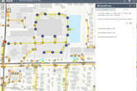
Once the Network Trace widget is added to your Web AppBuilder, you can configure the Illicit Discharge Trace app to discover potential polluters upstream of a source point.
To configure the Illicit Discharge Trace app, complete the following steps:
- Create an app from the Illicit Discharge Trace map and Web AppBuilder (Developer Edition) with the following settings:
- Name: Illicit Discharge Trace
- Description: This app uses a point location (flag) to trace the stormwater network upstream and discover potential stormwater polluters. The results of the trace are then saved to a CSV file.
- Configure a new Network Trace widget with the following settings:
- Widget Name: Illicit Discharge Trace
- Task URL: The REST URL to your published Upstream Trace geoprocessing service
- Configure the Input parameter using the following settings:
Input Settings Flags Tooltip: Input locations from which to start the trace.
Type: Flag
Symbol: Select a symbol
- Configure the Output parameters using the following settings:
Output Settings Connected_Inlets Label: Connected Inlets
Tooltip: Inlet locations returned from the trace.
Display text: Inlet Type: {INLETTYPE}; Access Type: {ACCESSTYPE}
Min scale: 0
Max scale: 0
Export to CSV: Disabled
Save to layer: Disabled
Symbol: Select a symbol
Connected_Mains Label: Connected Mains
Tooltip: Mains returned from the upstream trace.
Display text: {FACILITYID}: {DIAMETER} inch {MATERIAL} gravity main
Min scale: 0
Max scale: 0
Export to CSV: Disabled
Save to layer: Disabled
Symbol: Select a symbol
Selected_Businesses Label: Selected Businesses
Tooltip: Business locations returned from the trace.
Display text: {Business_N}: {Address}
Min scale: 0
Max scale: 0
Export to CSV: Enabled
Save to layer: Enabled
Target layer: PotentialBusinesses
Symbol: Select a symbol
- Configure the Summary using the following settings:
- Summary text:
{Connected_Inlets:Count} inlets are upstream from this location.
{Selected_Businesses:Count} are in close proximity to the storm inlets.
- Summary text:
- Configure the Overview using the following settings:
- Visible: Disabled
- Buffer Distance: 50
- Buffer type: Select an option
- Unit: Feet
- Min scale: 0
- Max scale: 0
- Save to layer: Disabled
- Configure the Other parameters to set the highlight image parameters, button text, and zoom options.
- Update the app's attributes to meet your utility's needs and branding.
- Save the application.
- Deploy the app and register the app to your ArcGIS organization.
- Title: Illicit Discharge Trace
- Thumbnail Image:
- Summary: App to determine the potential polluters upstream of a pollution source location.
- Description: This app uses a point location (flag) to trace the stormwater network upstream and discover potential stormwater polluters. The results of the trace are then saved to a CSV file or a feature service.
- Tags: Stormwater, Inlets, Illicit Discharge, Businesses