In order to use the Illicit Discharge Trace app at your utility, the upstream trace geoprocessing model needs to be updated with your local coordinate system, stormwater network, and business location data.
Upstream trace
To configure the Upstream Trace geoprocessing model, complete the following steps:
- In ArcCatalog, navigate to your download file > Maps and GDBs > IllicitTrace.tbx.
- Right-click the UpstreamTrace geoprocessing model and select Edit.
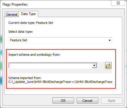
- For the Flags feature set, edit the properties and import schema and symbology from a network layer to ensure the coordinate system matches your network data.
- Configure the following variables with your feature classes or geometric network paths:
- swGravityMains
- BusinessLocations
- Stormwater Network
- Save changes before exiting and running the geoprocessing model.